Friday, April 19, 2013

4/19/13 - A Temperature Roller Coaster Ride

Article By:  Lester Rhoads
Ohio Weather Blog Long Range Forecaster


We've been on a temperature roller coaster for the last several weeks and that looks to continue as we go through the rest of April and into May.  We were in the low 80s in Cincinnati yesterday and the low 40s today with even a few sleet and rain showers this evening!  What a change...  Well what are a few of the factors driving this pattern and why is it lasting so long?

First of all we are still in a pattern that favors blocking.  In the below graphs, note the AO and NAO and how they take another dive as we hit May.


As you can see, this means more strong cold fronts with 2-3 day warm up's ahead of each system and 2-3 days of a cool down behind each system.  Wash, rinse, and repeat.   The latest computer models indicate another trough coming in for next week around mid week with an associated cold front due in on Wed.  We then, will see another system next weekend and there is more beyond that taking us into the first week of May. 

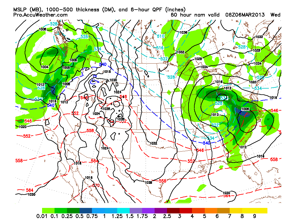
The pattern also looks to remain active.  Take a look at the 11-15 day 500 MB height anomaly map for the 11-15 day period.


As you can see, a ridge builds into the Rockies with a trough along the East Coast and over SE Canada.  There is a weakness in the atmosphere that places the Great Lakes and Ohio Valley regions right in the cross hairs for continues storm system with warm up's and cool down's continuing for the next few weeks. 

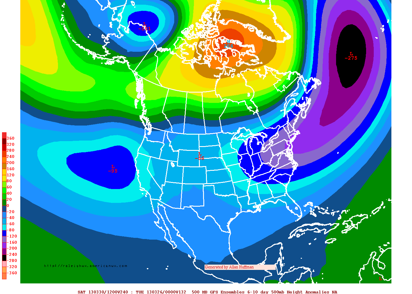
For comparison, here is the 6-10 day from the ECMWF model.


The Euro produces a much colder pattern with a positive PNA type of pattern with the ridge centered further west and the trough is centered right over the Ohio Valley.  This is a much colder outcome here with a strong North Atlantic ridge.  This is not a negative NAO by the way.  So there you have it! 

Thanks for reading and I appreciate your feedback!

Tuesday, April 9, 2013

Active Weather Times Ahead

Good afternoon folks!  The cold and dry weather pattern that we had last week is gone.  It has been replaced by a warmer and more active pattern more typical of Spring.  In addition to the storms this week across the Ohio Valley and Great Lakes regions, after we cool down a bit on Friday and this weekend, warm air will make a return for next week.  Both the GFS and ECMWF computer models indicate more storms will be in our future.  The GFS model tries to bring in the next cold front on Monday while the ECMWF does so by Tuesday.  Both models indicate an active second half of next week!

Do we have any cold spells for the second half of April?  We just might see one!  Check out the AO Forecast.

Ensemble Mean AO Outlooks

As you can see, it takes a dip and we get cooler (Friday and this weekend).  Then it rises for next week and takes another dip just after mid month.  I am watching that period, after mid month, to see if we get another cool down similar to the one coming later this week.  This is a classic spring time battle between the warm and cold so severe weather events will become more common for the rest of April and into May as well.

Check out the GFS Ensemble Mean for the 11-15 day period.  It also agrees with a cooler pattern developing after mid month.


Basically, what we can expect going forward is bouts of warmth and cold with an active weather pattern in between.  Severe weather will also become more of a threat as well.  Enjoy the nice weather if you're reading this from Cincinnati and enjoy the storm potential later on today if you live off to the North.

Tuesday, April 2, 2013

March 2013 Wrap Up from NWS Office in Wilmington

Hello everyone!  While on my lunch break at work today, I stumbled upon some cool information that might interest you.  We know March was an above avg snowfall month for the Ohio Valley and the month also features well below avg, temps. 

I found some cool graphics that the NWS Office in Wilmington posted on their facebook page.  The below graphics will show you snowfall departures for March as well as precip. and temps.


In addition, after we get through this week, the models are trying to show a wetter pattern developing for next week along with a warm up to above avg temps which we will be seeing this weekend across the Ohio Valley.  By mid month, there are signs of well above avg temps developing.  For information specific to Cleveland and Cincinnati, please visit the forecast page which Bryan and I are updating on a daily basis.


Friday, March 29, 2013

Easter Climatology From The NWS Office in Wilmington

I found this link on Facebook about Easter Climatology for Cincinnati, Columbus, and Dayton.  The article talks about temps and precip on past Easter Sundays. 

http://www.erh.noaa.gov/iln/climo/summaries/Easter/CVG.php

Info and article by The National Weather Service Office in Wilmington, Ohio

Have a great Easter Sunday from Bryan and I here at Ohio Weather Blog!


Tuesday, March 26, 2013

The Big Block Will Ease.... But More Cold Still?

Good evening everyone!  The massive -AO and blocking pattern that we have been seeing looks to weaken some as we head towards the end of March and into the start of April.   You can see that occurring by the graph below.


Does this mean that we will see a big time warm up?  The answer is simple.  No.  Why you may ask?  As the block eases we are going to see a massive ridge of high pressure, or block over Alaska.  This is known as a negative phase of the EPO.  A -EPO can sometimes allow for cooler then avg. temps over the Eastern US.  This feature looks to develop next week and continue for the next couple of weeks.  While we may see a few warm days every now and again over the next couple of weeks, the threat for significant and long lasting warmth, will most likely not occur.

You can see the big ridge below on the 500 MB anomaly map from this afternoon's 12Z GFS Ensemble model run.  This is valid for the 11-15 day period.


The 12Z ECMWF Ensembles also agree for the 6-10 day period.  You can see the ridge over by Alaska.


The bottom line is, if you're looking for sustained above avg. temperatures, or some fun tracking a lot of severe weather in the Ohio Valley, chances are you won't be a happy camper until we get deep into April or once we get into May.

Lester Rhoads
Long Range Forecaster
Ohio Weather Blog

Wednesday, March 20, 2013

The Calendar Says Spring...

Good evening everyone!  The calendar says Spring, and in fact the new season got underway this morning.  However, this post will attempt to explain why we are not seeing spring like weather as winter still has a firm grip on a large part of the country. 

The main cause for the winter like weather is due to the AO and the NAO both being severely negative.  The AO is the most negative that we have seen in a long time and for late March, it is the most negative that we have seen since record keeping began!  The index value from yesterday came in at a whopping -5 and it could bottom out at -6!  The AO when in a negative phase causes the polar vortex to be displaced to the south, along cold, arctic air to invade the Lower 48.  With the NAO also being very negative, the cold pattern has been able to stick around for a while.

Here is the forecast for the AO for the next two weeks as predicted by the GFS Ensemble Model from this afternoon's 12Z run.  *Image courtesy of Allan Huffman*


As you can see, the model shows the AO finally rising to positive values by the time we get into April so we could see a bit of relaxation in the cold weather by then.  Next, let's take a look at the NAO.  It has also been very negative but the various computer models do show a tendency for it to rise as well from this afternoons 12Z run.

*Image courtesy of Allan Huffman*


Based on these two teleconnection indices, we should see a little warmer weather ahead.  I do think, however, that we won't see significant changes until we get into April a little bit as far as above normal temperatures go.  But once we do see some warmer air move in, severe weather will become a concern and I will have more information down the road for you on that, once we get closer.

The 12Z GFS Ensemble Mean shows the cold pattern nicely through the end of March as you can see in the image below.


As you saw earlier in this post, that when the AO and NAO rise I mentioned that the pattern should turn a little bit warmer.  Well, let's take a look at the GFS Ensemble Mean for the 11-15 day period.


The pattern does not look at cold as it has been.  You can see the blocking as weakened and the large, cold trough has lifted out of Ohio.  This will be a slow warming trend once we get into April and the GFS Ensemble Mean clearly shows this. 

In conclusion, look for the winter like pattern to continue through the end of March with a slow moderating trend as we get into April.  Severe weather season is coming and I will alert you to that threat as conditions warrant.

Lester Rhoads
Ohio Weather Blog
Long Range Forecaster


Sunday, March 17, 2013

Intersting weather

Well as you guys know it winter is not done yet....

We have a winter weather advisory for the eastern sites. We can ecpect some ice and light snow amounts there. Below 1in maybe 2 in select spots. Behind this system we will see some snow showers( lake effect) and this could add up to some extant. Here is what the name is saying. It looks pretty good on snowfall amounts in the snowbelt but this will have to be watched.

More to come.

Bryan Polivka
Cleveland Ohio
Ohio Weather Blog Forecaster

Saturday, March 16, 2013

Neo Weather Forecaster

Calling all Weather Geeks!
 Have you ever wanted to forecast? Well if you do NEO Weather is looking for a forecast for the Cincinnati Weather Office. Here's the link to check out there page. http://neoweather.com/Cincinnati/

If you want to become a forecaster just go under the info tab and select jobs. You only do it once or twice a week. They have a great crew to work with so head on over and check them out!!!! And plus we are always looking to add great people to the team!

Friday, March 15, 2013

The AO, NAO, PNA, QBO and YOU!
Co-Written By:  Lester Rhoads and Bryan Polivka
This article will focus a little bit on that as well as the active and stormy pattern that is ongoing and will continue for the rest of March.
First, let’s look at the AO. It will continue to be negative but it drops to around -4 to -5. If this blocking continues this may push the storm track to the south and allow for the cooler weather to continue. But at the same time this may lead to a few more light snow showers for folks in Northern Ohio. If the AO rises some, then we might get into some severe weather events across the Southern portions of the Ohio Valley.

Now, we will look at the NAO. It will be mostly negative. That means a trough will persist over the eastern us. This will allow for some cooler temps but as I said above, the storm track will be south and west and this may end up giving us some more rain. It could be heavy at times and cause some flooding issues.

Looking at the latest PNA, it will continue to drop around -1 and -2 by the middle to the end of the month. We might see a ridge starting to develop across the eastern us and this might bring us back to normal or above normal late this month.   But for now, I believe that the –AO / -NAO combo, will offset the –PNA to a degree that a sustained warm pattern will not develop for the Great Lakes and Ohio Valley regions for the next few weeks.  The combination of the three things will allow for an active pattern to continue with the storm track over the Midwest and Ohio Valley regions.  Our current storm system will slow moving fronts and large temperature gradients will deliver the goods in bringing in numerous high precip. events.


Below is the 500 MB Height Anomalies from the ECMWF and GFS long range models. Both are showing a  very active pattern setting up with a –PNA, -NAO, and –AO.  As I explained above, this combination of features will bring active weather to our part of the country.

The last thing that I want to talk about is the QBO.  This was a big factor in bringing in the cold for the second half of winter and this also triggered the –AO and –NAO that started in February and is still continuing right now.  Last Fall, the QBO was strongly negative and you want a –QBO to help promote high latitude blocking.  The QBO was too negative so we had to wait until it rose.  Once that happened, we were able to get the AO and NAO to tank and as you have seen so far for March, we are still seeing those effects in the atmosphere.  Below are the QBO values from last fall through February.

September:  -26.60
October:  -24.51
November:  -18.95
December:  -10.02
January:  -6.07
February:  -1.23
In conclusion, get ready for mainly below average temperatures for the rest of March along with above normal precip.  We still will see a nice day or two every now and again, but if you’re looking for a 5-7 day period of dry weather and 60s and 70s for temperatures, then I’m afraid you’re going to have to wait a while.

Wednesday, March 13, 2013

3/13/13 - Global SST's

Below is an image of the current Global SST Anomalies for the globe.  You can clearly see the -PDO and the Enso Neutral conditions that I have outlined in the graphic.


Tuesday, March 12, 2013

Stalled front will cause big changes in temps forecast from Clevland to Cincinnati

Here is the ECMWF showing that stalled front just south of Ciny.
This will cause on and off showers for any one south of Columbus Sunday afternoon and evening.
Bryan Polivka
Ohio Weather Blog Forecaster

Ever Wondered on how the forecast is made?

Well there is many different things that go into a forecast. Here is a step by step approach.

1. Is look at the upper levels. From 300MB down to aleast 700MB. Are there trofs, ridges, jet streaks? Is that jet streak producing lift and rain at the surface? Is there warm air advection or cold air advection?

2. look at the surface map/radar. Look for fronts, high pressure systems, low pressure systems? Is there rain or snow. Is there warm air advection or cold air advection.

3 look at the models. See if they line up with what the surface map is say. Look at the upper levels too to see if they line up with the jet stream.

Than make your forecast based on all the data you looked at and use upstream wx stations also to determine the temp patterns.

That's all for now. But if you have any questions leave them in the comments section or e-mail me at b163@live.com. Thanks so much for reading.

Bryan Polivka
Ohio Weather Blog Forecaster
Cleveland Ohio

Sunday, March 10, 2013

3/10/13 - What Does NW Flow Mean?

Some of you may have heard the term "NW Flow" used in Meteorology when it comes to describing a weather pattern.  I used it if you check out my post this morning on the Cincinnati Forecast Page.  The term, NW Flow means exactly what it says.  You typically will see a ridge of high pressure over the Western US with a trough centered over the Eastern US.  The jet stream rides up and over the Western US ridge, then dives SE out of Canada to form the trough over the East.  Thus, our flow here in the Eastern US is coming straight our of Canada, or a NW Flow in the upper levels of the atmosphere.  Typically, this pattern brings cooler then average weather and dry conditions.  This weather pattern is what we will be seeing next week.

Here is what the jet stream looks like by Tuesday of next week from the 0Z run of the GFS forecast model.  I have pointed out some things on the model image for you to illustrate what a NW Flow pattern looks like.


Lester Rhoads
Ohio Weather Blog Forecaster
Burlington, KY

Thursday, March 7, 2013

3/7/13 - Snowfall Data for Cincinnati and Cleveland

With winter coming to a close, and spring being right around the corner, I thought I would share with you all the snowfall data for Cincinnati and Cleveland.  Below, you will see how much snowfall data for the entire winter season through today at 5pm.  In addition, you will see the snowfall departure and where we stood snowfall total wise at this time last year.

Cincinnati (KCVG)

Total snowfall for the winter season:  21.3"
Normal snowfall:  19.5"
Departure:  +1.8"
This time last year we only saw 5.6" of snowfall.

Cleveland (KCLE)

Total snowfall for the winter season:  43.5"
Normal snowfall:  55.5"
Departure:  -12.0"
This time last year we only saw 38.5" of snowfall.

NOTE:  Data was obtained from the NWS Office in Wilmington and Cleveland, OH.  Numbers are based on today's 5pm climate report.

For KCVG:  http://www.nws.noaa.gov/view/prodsByState.php?state=OH&prodtype=climate#CLICVG
For KCLE:  http://www.nws.noaa.gov/view/prodsByState.php?state=OH&prodtype=climate#CLICLE

Wednesday, March 6, 2013

3/6/13 - NWS Wilmington Snowfall Summary

The National Weather Service in Wilmington, issued a nice snowfall summary map with reports on this winter storm.  Check it out!
 
http://www.erh.noaa.gov/er/iln/events/20130305/

Lester Rhoads
Ohio Weather Blog Forecaster
Burlington, KY

Tuesday, March 5, 2013

Updates Snowfall Forecast

I-70 around Dayton - 8-10"
Northern Cincy Tri-State couinties:  6-8"
Cincy Metro:  5-7"
Southern Counties:  3-5"

Lester Rhoads
Burlington, KY
Ohio Weather Blog Forecaster

Weather Discussion 3/5/13


Interesting day here in northeast Ohio. The snow should stay just to the south of us tonight. With that said took down snow accumulations to around an inch at best. This system will deepen and then transfer its energy to an east coast storm. We have an upper level low that is racing towards southwest Ohio and as this happens we will see the best dynamics (upper level vort max and closed low) over the southwest portion of Ohio. Some areas could receive up to 8 or 9 inches. The rain is now turning over to snow and that will continue thought out the evening from northwest to southeast.  High pressure will build back in got the rest of the week. Could be seeing highs approaching 50 by Sunday for Cleveland and Cincinnati could reach 60. It will be a good week to get out and do outside actives like washing your car or going fishing with the kids. The next chance of rain will come late Sunday and into Monday.
Bryan Polivka
Cleveland Ohio
Ohio Weather Blog Forecaster

Weather Forecast Cleveland 3/6/13-3/13/13

Weather Forecast for Cleveland Ohio

Wednesday: 34 Mostly cloudy than becoming partly cloudy in the afternoon.chance of snow near 30%

Wednesday Night: 26 Partly Cloudy

Thursday: 36 Partly Cloudy

Thursday Night: 25 Mostly Clear

Friday: 40 Mostly Sunny

Friday Night: 25 Mostly Clear

Saturday: 46 Mostly Sunny

Saturday Night: 33 Mostly clear early than becoming mostly cloudy after 1am

Sunday: 51 Mostly Cloudy  then rain likely after 1 pm chance of rain 40%

Sunday Night: 38 Cloudy with rain showers chance of rain near 90%

Monday: 48 Rain showers in the morning than rain and snow after 1pm chance of precip near 90%

Monday Night: 32 Snow showers likely chance of snow 40%

Tuesday: 33 Mostly cloudy

Tuesday Night: 28 Mostly cloudy snow showers mainly after 10 pm chance of snow near 30%

Wednesday: 28 Mostly Cloudy

Bryan Polivka
Cleveland Ohio
Ohio Weather Blog Chief Forecaster

Les's Snowfall Forecast for The Southern Half of Ohio

***Winter Storm Warning in effect for the coverage area until 1pm tomorrow***

The changeover from rain to snow will occur over the next couple of hours from NW to SE across the region.  I expect 2-4" across the far Southern areas....  4-6" across the Cincy Metro..... 6-8" across the far North.  Those 8" totals look to fall across I-70 from Richmond, IN to Dayton, OH  More later! 

Lester Rhoads
Ohio Weather Blog Forecaster
Burlington, KY

18Z NAM Run- Snowfall Map


18Z NAM snow map showing that most of the heavier snow will stay north of Cincinnati.  One area that will get hit the hardest is Mercer County where up to 7-10 inches possible. Will have more information later this evening.
Chief forecaster- Bryan Polivka
Cleveland Ohio
Ohio Weather Blog  Chief Forecaster

Monday, March 4, 2013

0Z NAM Model Up's Totals....

Cleveland forecast discussion


CLEVELAND FORECAST DISCUSSION
947PM 3/4/13 UPDATE
00Z NAM AND 21Z SREF HAS SHIFTED SOUTH AND THAT WILL RESULT IN LESS SNOW THAN EXPECTED SO UPDATED THE FORECAST TO SHOW THIS . LESS THAN 2 INCHES EXPECTED FOR CLEVELAND. STAY TUNED FOR MORE UPDATES......

INTERSTING WEATHER PATTER SETTING UP FOR THE AREA THE NEXT FEW DAYS. THE MODELS AT 18Z WENT SOUTH WITCH TOOK THE SNOW RIGHT WITH IT. STILL LOOKING AT A GERNNERAL 1-3 INCHES FOR NORTHEN OHIO AND NORTHEASTERN OHIO. THE EURO HAS BEEN VERY CONSISTANT WITH THIS TRACK AND WILL FOLOW THAT ONE AND A BIT OF THE GFS. THERE IS SOME DRY AIR TO WORK WITH SO SOME SLEET MAY MIX IN AT THE START OF IT. THE SOUHTERN PORTION OF THE CLE NWS AREA MIGHT SEE SOME RAIN AND SNOW MIX BEFORE CHANGING TO ALL SNOW OVERNIGHT. 850 HEIGHT TEMPS DO WARM TO ABOVE FREEZING FOR THE SOUTNER COUNTIES AND DO EXPECT TO SEE SOME SLEET TO MIX IN. HIGH PRESSURE WILL BE BUILDING IN FOR WEDNESDAY NIGHT AND INTO THURSDAY. A RIDGE ALOFT WILL BE BUILDING AND ALLWOING FOR WARMING TEMPS. HIGHS WONT BE TO WARM BUT MUCH ARMER THAN THEY HAVE BEEN. WE COULD BE FILTERING WITH THE LOWER 50S ON SATURDAY AND SUNDAY DEPENDING ON HOW SUN WE CAN GET AND HOW STRONG THE SOUTH WINDS ARE. THE GFS AND THE ECMWF DIFFER ON THE NEXT SYSTEM. GFS SHOWES RAIN BY SUNDAY AND MONDAY AND THE EURO IS NOT SHOWING ANYTHING TILL TUESDAY. HAVE KEPT A 30% IN THER FOR NOW AND WILL FINE AND TWEAK THAT AS THE WEEK GOES ON.
FORECASTER- BRYAN POLIVKA

Weather Forecast Cleveland 3/5/13-3/12/13

Weather Forecast for Cleveland Ohio

Tuesday: 34, Mostly cloudy, snow showers mainly after 6pm chance of snow 30%

Tuesday Night: 29 snow showers little or no snow accumulation chance of snow 30%

Wednesday: 35 snow mainly before 10 am. snowfall around 1/2 inch. chance of snow near 30%

Wednesday Night: 28 mostly cloudy than becoming partly cloudy

Thursday: 38 partly cloudy becoming mostly sunny in the afternoon

Thursday Night:25 mostly clear

Friday: 41 mostly sunny

Friday Night: 30 mostly clear

Saturday: 45 partly sunny

Saturday Night: 30 parlty cloudy

Sunday: 48 partly cloudy

Sunday Night: 34 parlty cloudy

Monday: 50 parlty cloudy chance of rain 30%

Monday Night:36 parlty cloudy chance of rain 30%

Tuesday: 45 mostly cloudy chance of rain 40%

Bryan Polivka
Cleveland Ohio
Ohio Weather Blog Forecaster

First Call Snow Map

Hi everyone!  Bryan and I will be working on the forecast for you.  Here is our first call snow map.  This is for snowfall totals between 7pm Tuesday through 1pm Wednesday.  This period is when the bulk of the snowfall will come.


Storm Time Line:

This evening and tonight:  Just a few sprinkles and flurries.  A mix of snow and rain develops by morning changing to all rain across Southern Ohio.  Across Central Ohio, a mix of snow and rain will be possible with all snow across the North moving in by afternoon.  Everyone is all snow Tuesday night into Wednesday with the changeover occurring for the I-70 Corridor in the late afternoon hours and around the late evening hours for places across the South.  Snow will be taper off from NW to SE during the day on Wednesday and by noon, most everyone should be snow free.

This forecast is likely to change so stay tuned!

Lester Rhoads
Burlington, KY
Ohio Weather Blog Forecaster

Wx update 3/4/13


Just a quick update….the NAM has shifted a bit south on the 18z run. This will impact our forecast and we will continue to update you this evening. Cleveland my get up to 4 inches and along the 1-70 corridor they my see up to 6 inches. More to come this evening stay tuned….
Bryan Polivka
Cleveland Oh
Ohio Weather Blog Forecaster

Sunday, March 3, 2013

Winter Storm 3/5/13-3/6/13


As you all now or have heard of the storm that we might get Tuesday night and into Wednesday is looking like the norther section of Ohio will get hit. Looking at the NAM model it is showing at 60hrs that the low will be over north central Ohio. This low will then die out and transfer its energy to the low that is over the southeastern us. You can see the upper level low over southern ohio and this will also aid in the heavier snow fall in the northern counties.

Now the GFS at 60 hrs it has the surface low just a bit south and east of where the NAM has it. The American models are north while the ECMWF is a bit further south. I don’t think the ECMWF is correct and this will need to be watched.


Thats all for now. Make sure you come back later for more information on this storm.

Bryan Polivka
Cleveland, OH
Ohio Weather Blog Forecaster

3/4/13 - Winter Storm to Impact Ohio for Tuesday and Wednesday

A winter storm is currently developing over Montana and Minnesota.  This storm will be dropping SE towards the Great Lakes region and Ohio Valley bringing with it snow and rain.  Accumulating snow will fall North of I-70 with moderate accumulations possible.  Further to the South, the storm will begin Monday night with snow across the SW part of the state.  Snow will spread across the rest of the state on Tuesday with precip. changing to rain across the Southern half of the state.  Snow will continue across the North.  Rain will change back to snow Tuesday night into Wednesday across the South as the surface low pressure system finally passes through NE Kentucky or SW Ohio.  Total accumulations across the state by Wednesday afternoon will range from 4-8" across the North and 1-3" across the South.

For those who are tired of winter, Spring is just around the corner with a big warm up coming for the end of next week!  In fact, temperatures will be near 60 across the South with low 50s across the North. 

Thanks for reading!

Lester Rhoads
Burlington, KY
Ohio Weather Blog Forecaster

Welcome


Welcome to Ohio Weather Blog.

Here we will post on current weather, forecast and other interesting weather stuff.

We have two forecasters: Bryan Polivka and Lester Rhoads both with weather forecasting experience. Lester is a long range weather forecaster also. Bryan is a general weather caster and winter weather expert.

Thanks for checking in and we will have more stuff to come.

Bryan and Lester